Tuesday, May 3, 2011

Chapter 18: Hawaii

     Arizona is probably the most opposite state of Hawaii.  Their topography, their climate, their agriculture, and their population are far from similar.  However, both Hawaii and Arizona are both under heavy government land ownership.  Roughly half of all land in Hawaii is government owned, with the state, not the federal government, controlling 80 percent of that land.  Most of it is in the agriculturally less desirable portions of the islands, and the bulk is in forest reserves and conservation districts.  Most federal lands are primarily in national parks on the Big Island and Maui, or in military holdings on Oahu and Kahoolawe. (http://countrystudies.us/united-states/geography-23.htm)


     This map of land ownership in Arizona shows that most of the land is under government control.  The red being the only privately owned land in the state.  The white represents federal land, the blue state land, and the brown, a major portion, tribal land.

Chapter 16: The North Pacific Coast


     Stretching from northern California to southern Alaska, the North Pacific Coast has little in common with the region's physiology.  The region is home to several plateau's including the Snake River Plateau, and river systems, which, like Arizona's, are major resources in the production of hydroelectric power.  Begun two years after the start of construction of the Hoover Dam and also under the autorization of Roosevelt, the Coulee Dam was built for the production of hydroelectric power and irrigation, impounding water from the Columbia River with a flow volume larger than the Mississippi River.  It has become the largest electric-power producing facility in the US (http://en.wikipedia.org/wiki/Grand_Coulee_Dam).  The regions high precipitation and rugged topography provide the North Pacific Coast with a hydroelectric potential power unlike anywhere else in America.  Forty percent of the US's potential is contained in Oregon and Washington alone (Regional Landscapes of the US and Canada [textbook])


     Like Arizona, the region was home to a relatively large Native American population prior to European settlement.  The Native Americans of the region were provided with a plentiful supply of deer, berries, roots, shellfish, and salmon.  Unlike the Native Americans of Arizona and the rest of the southwestern and eastern regions of the United States, Native American tribes of the North Pacific Coast were unable to form an organized opposition because of each tribe's isolation.  This led to their quick and quite disappearance. (http://www.america.gov/st/peopleplace-english/2008/May/20080618212828eaifas5.130512e-02.html)

Chapter 15: California

(The Colorado River diving California and Arizona)

     California and Arizona are similar in many ways.  Both share a border with Mexico, contributing to their large Mexican population.  Both their agriculture relies heavily on irrgated water.  California and Arizona also share the water that borers them.


(Parker Dam, Arizona)
 
     The Colorado River is a major source for both California and Arizona.  Much of  southern California's drinking water comes from the Colorado River Aqueduct, which also provides water for central Arizona.  Along the Colorado River are several dams that utilize the water for hydroelectric power for both Arizona and California.  The dams most contributing to California's power are the Hoover, the Imperial, and the Parker Dams. (http://en.wikipedia.org/wiki/Geography_of_Arizona#Rivers)


     California also helps Arizona out in a big way.  Arizona receives 60% of its gasoline the Arizona's West Line that runs from Los Angeles to Phoenix.  It takes 7 days for a gallon of gasoline to reach Phoenix through the West Line. (http://www.azgovernor.gov/estf/distribution.pdf)


Chapter 14: The Southwest Border Area


     Stretching from Southern California's Pacific Coast to Texas' Gulf Coast, completely engulfing the state of Arizona, the Southwest Border Area is a diverse culture region of coexisting Spanish American, American Indian, and Anglo cultures.  Both Native American and Spanish cultures have coexisted in much of the area since the arrival of the Spanish at the end of the 16th century before the immigration of Anglo cultures in the 19th century. (http://www.america.gov/st/peopleplace-english/2008/May/20080618211737eaifas0.8352472.html)


     Large-scale Anglo settlement was most likely discouraged well into the 19th century because of Arizona and it's surrounding regions' dry, arid climate.  This ensured that a large number of Native Americans remained in the area.  The largest tribes of the region are found in Arizona: the Navajo in the Four Corners Region, where the states of Arizona, Colorado, Utah, and New Mexico meet, the Apache, the Papago in southern Arizona, and the Hopi in northwestern Arizona. (http://www.america.gov/st/peopleplace-english/2008/May/20080618211737eaifas0.8352472.html)


     Despite it's climate, the region continues to boom in population.  Arizona was the third most rapidly growing U.S. state on a percentage basis in the 1980s, following only Nevada and Alaska.  All of the region's states during this period grew at a rate well above the national average. The city of Phoenix has doubled in size several times since 1950.  Since 2000, Arizona's population has increased by almost 27%.  Phoenix, the largest populated capital in the United States, grew 31% in population from 2000 to 2008.  It is now the 6th largest city in the United States. (http://phoenix.about.com/cs/living/a/census01_2.htm)

Chapter 13: The Empty Interior


     The Empty Interior of the US stretches from the eastern slopes of the Rocky Mountains west to the Sierra Nevada of California, the Cascade Range of the Pacific Northwest, and the Coast Mountains of British Columbia.  The name "Empty Interior" is derived from the areas low population density across its space.  Arizona is completely encompassed by the Empty Interior.


     The terrain of the Empty Interior is much more rugged than that of the eastern United States.  Younger mountain ranges result in higher elevations and more pointy, rugged peaks.  Glacial carving also played a major role in the western Interior's topography. (http://www.america.gov/st/peopleplace-english/2008/May/20080618210046eaifas0.9248011.html)


     The Empty Interior is home to more plateaus than mountains.  The Colorado Plateau encompasses half of Utah and nearly half of Arizona's total land.  

 
     A substantial part of America's total national park system is found in the interior West, including such famous parks as Yellowstone, Glacier, and Arizona's Grand Canyon.  But the national parks are only a small portion of the total public land area.  The largest share of these lands is held by the Bureau of Land Management, a part of the U.S. Department of the Interior, which puts this land to many uses, grazing being the most important.  The bureau has also been the main agent in the construction of irrigation and hydroelectric dams in the area.  Arizona is home to some of the most complex irrigation systems and hydroelectric dams.  Over 80 percent of the water from these federally supported projects is used to irrigate over 4 million hectares.  (http://www.america.gov/st/peopleplace-english/2008/May/20080618210046eaifas0.9248011.html)


Chapter 12: The Great Plains and Prairies


     Grasslands in northern Arizona are actually closely related to the Great Plains. The vegetation of this section is usually thought of as being the western extension of the short-grass plains that occupy a region just east of the Rocky Mountains.   


     About 30 years ago, grasslands covered nearly 25 percent of the state.  But invasion by plant species from other proximate vegetation associations may have reduced the area covered by grasslands.  Arizona has three types of grassland: mountain meadow, plains and desert. Mountain meadow grasslands are scattered throughout the spruce-fir and montane forests at elevations ranging from 7,500 to 10,000 ft. The plains grassland extends southwest into Arizona where it grows mostly in the northeast as nearly uninterrupted ground cover between 5,000 and 7,000 ft.  The desert grassland is principally in southeastern Arizona between about 3,000 to 5,000 ft. (http://southwest.library.arizona.edu/azso/body.1_div.4.html)

Chapter 11: The Agricultural Core


     The Agricultural Core's environmental conditions make the area best suited for the production of corn.  Corn was also once a reliable food source for Native Americans living in Arizona.  Evidence of the first farmers in the region has been found in the rich alluvial valleys of Cochise County dating from around 2,000 BC.  At this time, corn or maize was first domesticated as a reliable food source. Ancient corn had separately sheathed kernels in a husk, attached to a small cob. Acceptance and cultivation of this ancestor of corn transformed human social and economic life from hunting and gathering to farming and trading. The simultaneous introduction of beans, chili and squash, along with corn, provided complete nutrition for early man. (http://southwest.library.arizona.edu/azso/body.1_div.1.html)


(Cotton Farm in Arizona)

     Despite its dry climate, agriculture is still a $9.2 billion industry, its top commodities being luttuce, cotton, and hay.  Arizona makes enough cotton a year to make more than one pair of jeans for every person in the US.  So if you're wearing pants, thank Arizona.  Arizona is also a valuable source of cattle and dairy goods, it being their most valuable farm product. (http://www.agclassroom.org/kids/stats/arizona.pdf)

Chapter 10: The Southern Coastlands


     The Southern Coastlands includes parts of Texas and Louisiana, 2 of the 3 leading petroleum-producing states (the third being Alaska).  Although 60% of Arizona's gasoline comes from its West Line- a 20 inch diameter pipeline that runs from Los Angeles through Southern California, Yuma, and ends in Phoenix- the rest comes from its East Line and Longhorn Pipeline that come from Gulf Coast refineries of the Southern Coastlands. (http://www.azgovernor.gov/estf/distribution.pdf)

     Arizona's East Line consists of two pipelines, one 8 inch and one 12 inch in diamater pipelines, running parallel to each other from El Paso, Texas to Tuscon, Arizona.  From Tuscon, the the two separate pipelines become one pipeline and stretch from El Paso to Phoenix.  The Newer Longhorn Pipeline runs from Houston to El Paso before connecting to the Eastl Line.  (http://www.azgovernor.gov/estf/distribution.pdf)
    

     Arizona is separated form the Southern Coastlands by New Mexico and most of Texas.  Unlike the Pacific Coastal regions of the United States, the Southern Coastlands are highly vulnerable to powerful hurricanes generated by the solar heating over the Gulf of Mexico.  

     Though less frequent, Arizona too can experience tropical storms just like the Southern Coastlands.  Unlike the Southern Coastal storms that originate in the Gulf of Mexico, tropical storms that have been known to affect Arizona originate in the Eastern Pacific Ocean.  Although most of these storms are carried away from or parallel to the Pacific Coast, Arizona still experiences the effects of tropical cyclones one every five years on average. (Corbosiero, Kristen L. (2003). "The Contribution of Eastern North Pacific Tropical Cyclones to the Warm Season Rainfall Climatology of the Southwestern United States". University of Albany)


Thursday, March 17, 2011

Chapter 9: The Changing South

(Flag of Arizona Territory)

     It is no secret that the South had a rather sketchy past.  Arizona also shares its past with the South during the Civil War era.  Between 1856 and 1858, several proposals were presented to the government to turn Arizona into a territory.  However, these were dismissed by congress out of their perception that Arizona was under the influence of southern sympathizers who wanted to expand slavery into the area.  Congress was afraid Arizona would become a slave state.  Fed up with congress at the start of the Civil War, two secession conventions were held, one in Mesilla, New Mexico and another in Tuscon, Arizona.  The conventions subsequently established a provisional territorial government for the Confederate "Territory of Arizona."   The Confederate Territory of Arizona became officially recognized when President Jefferson Davis signed the proclamation on February 14, 1862. To commemorate this event, February 14, 1912, the fiftieth anniversary, was selected as official date of statehood for Arizona.  (http://en.wikipedia.org/wiki/Arizona_Territory_(CSA))
 

Chapter 8: Appalachia and the Ozarks


     Although the state of Arizona is not a part of the Appalachia and Ozarks region, nor is it even close, Arizona actually has a lot to thank the area for in the creation of its own physiography. 


     The Colorado Plateau is a physiological region that encompasses the Four Corners area of Utah, Colorado, New Mexico, and almost the entire northern half of Arizona.  The formation of the Colorado Plateau actually shares its past with the Appalachians.  Creationists have employed provenance studies in tracing the long distance transport of rocks to determine the paleo flow regime and transport distance. For instance, powerful currents in the northern Rockies region of the United States eroded and transported quartzite rocks both east and west: up to 1,300 km to the east and about 640 km to the west.  This long distance transport phenomenon also applies to the formation of the Colorado Plateau. (http://creation.com/colorado-plateau-sandstones#endRef7)

    Studies suggest that the grains of the Navajo Sandstone on the Colorado Plateau originated from the Appalachian Mountains.  The Navajo Sandstone is one of the largest supposedly wind-deposited formations in the geological record and is estimated to have once covered up 400,000 km2, the size of the state of California.  (Pratt, S., Tracing the Navajo Sandstone, Geotimes 48(11):6–7, 2003)
    

Wednesday, March 16, 2011

Chapter 7: The Bypassed East


     After trying to find a relationship between Arizona and the Bypassed East region, I found they couldn't be more opposite.  Climate, temperatures, and physiography have little in common, except for both areas being home to mountain ranges called the White Mountains.  Both regions are, however, home to different species of White Pine.  Both also share a mining past as well.  Arizona had and still continues to have a successful copper mining industry while the Adirondack Mountains of the Bypassed East were once home to a 100 year mining period of Iron Ore.  Today, the reserves are still substantial, but outputs are low.  However, Maine does account for 80-90% of the nation's lobster catch.  So if you're eating lobster down in Phoenix, there's a good chance it came from the Bypassed East.

Chapter 5: The North American Manufacturing Core


     Although Arizona is not part of the United States' manufacturing core, it has had a successful mining past.  Arizona has experienced a successful copper and mining industry.  Silver was a big reason why Arizona was explored by the Spanish in the first place.  Silver ore was discovered by the Spanish in 1583 by Antonio de Espejo but was never mined.  It wasn't until 1853, after Arizona became under U.S. control, that mining for silver began at areas previously known to the Spanish.  Today, most of the silver deposits have been mined but Arizona still produces more silver than in its mining days but as a byproduct of mining for copper, a far more successful industry. (http://en.wikipedia.org/wiki/Silver_mining_in_Arizona)

     Copper has proved to be a better industry than silver.  The Morenci Mine is the state's top producer of copper to date.  The mine was opened in 1873 and is responsible for half of Arizona's copper production.  As of 2006, there are 11 copper producing mines in Arizona. (http://en.wikipedia.org/wiki/Copper_mining_in_Arizona)

Chapter 4: Megalopolis


     While Arizona isn't included in the United States' Megalopolis region of the East Coast, Arizona does have areas of dense population, urban lanscapes, and other characteristics of a Megalopolis.


     Phoenix is Arizona's largest city and state capital.  It is also the nation's 5th most populous city with 1.5 million residents and the nation's 14th largest metro area by population with over 4.1 million people.  It is also the most populated capital in the United States.  The early economy of Phoenix was primarily agricultural, dependent mainly on the "5Cs" which were copper, cattle, climate, cotton and citrus. In the last four decades most of the farmlands have been turned into suburbs, and the economy has diversified as swiftly as the population has grown.  Many residents in the area are employed by the government. ASU has also enhanced the area's population through education and its growing research capabilities.  Numerous high-tech and telecommunications companies have also recently relocated to the area. Due to the warm climate in winter, Phoenix benefits greatly from seasonal tourism and recreation, such as the golf industry. (Daniel Bubb, "McCarran International and Phoenix Sky Harbor International: Airport Expansion, Tourism, and Urbanization in the Modern Southwest")

     Phoenix's transportation systems have also progressed in recent years.  Phoenix and Tucson's metropolitan areas are served by public bus transit systems as well as a recently added light rail system called the Valley Metro Rail.  Phoenix also contains one of the nation's largest and fastest growing freeway systems with almost 1500 lane miles. (http://www.azcentral.com/arizonarepublic/viewpoints/articles/2008/09/07/20080907vip-lavsphx0907.html)

     Seven Fortune 1000 companies call Phoenix home as well as four professional sports teams including the Phoenix Coyotes, the Arizona Cardinals and Diamondbacks, and the Phoenix Suns.  

     The metropolitan area surrounding Phoenix is only going to get bigger.  According to urban researchers, Phoenix and Arizona's second largest metropolitan area (exceeding 1 million people) are due to merge within the next decade. (http://www.azcentral.com/arizonarepublic/news/articles/0409merge0409.html)

Chapter 3: Foundations of Human Activity


     Native Americans and the Spanish have an enormous impact on the history of Arizona.  Before the Hopi, the Apache, and the Navajo tribes that we see in Arizona today, Arizona was home to even older tribes such as the Anasazi and the Sinagua people.  Roughly 1,000 years ago, the Anasazi built complex, multi-family dwellings into cliff and canyon walls into the area they occupied now called the Four Corners Region.  For unknown reasons, the Anasazi abandoned their Arizona home in the 12th and 13th centuries.  In central Arizona, the Sinagua also began to build elaborate dwellings before completely disappearing by the end of the 14th century. (http://www.gatewaytosedona.com/article/id/1463/page/1)

     Today, the Hopi, believed to be direct descendants of the Anasazi, occupy their own 1.5 million acre reservation outside Flagstaff, Arizona.  As of 2000, their numbers are about 7,000 and are divided into several matrilineal clans.  Making up a majority of Arizona's Native American population today are the Navajo, who as part of a larger group, migrated into the Four Corners area between 1000 and 1200 AD.  Their nation today includes aproximately a quarter million people within a 27,000 square mile area, surrounding the Hopi reservation. (http://www.gatewaytosedona.com/article/id/1463/page/2)

     The Spanish arrived in the 16th century in search of gold.  Legend says that during the Moorish invasion, seven bishops fled Spain and founded seven cities in the territory north of Mexico.  Upon hearing these rumors, a Spanish Franciscan Friar by the name of Marcos de Niza came in search of these Seven Cities of Gold.  From 1810 to 1821, during the Mexican war of independence from Spain, Arizona came under Mexican control. Then, in 1848, in the Treaty of Guadalupe Hidalgo, Mexico relinquished control to the United States. In 1863, Arizona was organized as a separate territory. It attained statehood in 1912. (http://www.destination360.com/north-america/us/arizona/history-of-arizona)


    Today, several Arizonan traditions continue with their Native American and Latin Cultural heritage.  One example is the celebration of Dia de los Muertos which is celebrated in October throughout various Arizona locations.  Arizona state facts also exhibit signs of its past.  The state gem is turquoise which was widely used in Native American jewelry.  The state flag's red and gold colors represent the colors worn by Spanish explorers while in search of the seven cities of gold.  (http://www.destination360.com/north-america/us/arizona/history-of-arizona)

     The earliest religions of Arizona were obviously those of its earliest inhabitants, the Native Americans.  Today, a majority of inhabitants are of the Christian faith, probably due to the Spanish missionaries who converted many Arizonan Indians.  In 2000, Catholics numbered at approximately 975,000.  The Church of Jesus Christ of Latter-day Saints (Mormons) constitutes the 2nd-largest Christian denomination with 251,974 adherents in 643 congregations. Mormons were among the state's earliest Anglo settlers. Other major Christian denominations include the Southern Baptist Convention, 138,516 adherents; Assemblies of God, 82,802; and the United Methodist Church, 53,232. (http://www.city-data.com/states/Arizona-Religions.html)

Chapter 2: Geographic Patterns of the Physical Environment


     Most people, all two of them, who have asked me where the most beautiful place I have been are shocked when I respond with "Arizona".  To them, all two of them, Arizona seemed like an empty, desolate state with nothing to look at other than the Grand Canyon.  On the contrary, Arizona is an amazing place to experience physical geographic beauty.  Hawaii is overrated. 


     Like the Intermontaine Basin and Plateau Region in which Arizona is located, it too is divided into three subregions: the Colorado Plateau, the Transition Zone, and the Basin and Range Province.  The Colorado Plateau is a semi-arid and mostly flat-lying area ranging from 5,000 to 8,000 feet in elevation and encompassing nearly all of the entire northern half of Arizona at 140,000 square miles.  The Colorado River played a major role in the plateau's geology.  The Grand Canyon is one of the major features of this region.  The Transition Zone is the clever name given to the transitional zone between the Colorado Plateau and the Basin and Range Province.  The Transition Zone is a northwest-trending escarpment or moutainous terrain that actually has characteristics of its surrouding regions.  The area consists of several mountain ranges, including the White Mountains and the Sierra Ancha.  Because of its range of elevation, the area receives heavy rainfall and varying climatic conditions.  The Basin and Range Province includes the entire southern half of Arizona and the western borders of the state.  The Basin and Range is characterized by steep, linear mountain ranges alternating with "lengthy" deserts.  ( Wikipedia <http://en.wikipedia.org/wiki/Geography_of_Arizona#Physiographic_regions>)


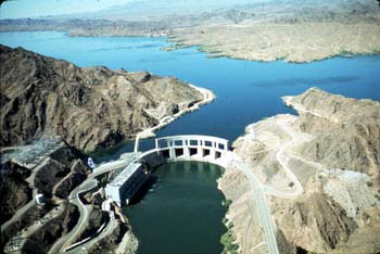
     Arizona's major features also include its deserts and rivers.  The Painted Desert is located on the Colorado Plateau and covers 146 square miles.  The Sonoran Desert, one of the hottest in the country, is located in the southwestern portion of the state and includes the cities of Phoenix, Tuscon, and Yuma.  Despite being the state with the second lowest water area, Arizona is home to an impressive river system.  It's most popular and major resourceful river, the Colorado, is vital for Arizona's irrigation and also plays a major role in the production of hydroelectric power through the use of several dams along its route.  (Wikipedia <http://en.wikipedia.org/wiki/Arizona>)

    Arizona's climate is another reason why I enjoy it so much.  The climate varies because of its large area and changes in elevation.  High temperatures are common throughout the summer months at the lower elevations.  In the desert, temperatures as high as 125 degrees F can be reached.  Great extremes occur between day and night temperatures throughout the state as well.  The daily range between maximum and minimum temperatures can be as much as 50 to 60 degrees F during the drier portions of the year.  During winter months, daytime temperatures may average 70 degrees F, with night temperatures often falling to freezing of slightly below in the lower desert valleys.  (http://www.wrcc.dri.edu/narratives/ARIZONA.htm) 

     Our textbook classified Arizona's soil as aridisols, this meaning that the soil is relatively low in organic matter and with little agricultural value.  Minerals are the major constituent in Arizona soils and are derived from the parent material by weathering (http://southwest.library.arizona.edu/azso/body.1_div.6.html).  Despite this, Arizona has 3,666 species of native and naturalized plants in 1,003 genera and 145 families. The composites, the grasses, and the legumes constitute the three largest families.  The state is divided into several vegetation zones including: the Spruce-Alpine Fir Forest zone, the Montane Conifer Forest zone, the Riparian Deciduous zone, the Pinyon-Juniper Woodland zone, the Encinal and Mexican Oak-Pine Woodland zone, the Interior Chaparral zone, and the Grasslands zone. (http://southwest.library.arizona.edu/azso/body.1_div.4.html)

Chapter 1: Regions and Themes


     Our book suggests with the Ohio State University experiment, in which students were asked to identify regions of the United States, that regions can vary depending on who you're asking and what you're defining.  For example, concerning the Southwestern region of the United States, Arizona is almost always considered at its core along with New Mexico.  However, depending on who you're asking, California, Nevada, Utah, Colorado, Texas, and Oklahoma are all sometimes considered to be part of the Southwest regions.(Wikipedia <http://en.wikipedia.org/wiki/The_Southwest> )


     Concerning the physiography of North America, Arizona falls into the Intermontaine Basins and Plateaus region.  Sandwhiched between the pacific mountains and valleys to the west and the Rocky Mountains to the east, the Intermontaine Basins and Plateaus region spans from western Texas and all the way to Alaska.  The area is divided up into three subregions including: the Columbia Plateau, which encompasses eastern Washington, eastern Oregon, and southern Idaho; the Colorado Plateau, which includes parts of Colorado, Utah, New Mexico, and of course, Arizona; and the the surrounding basin and plateau areas in and between both plateaus.  The Colorado Plateau, which encompasses almost the entire northern half of Arizona, features high plateaus and mesas dissected by extensive, steep-sided canyons. The remainder of the region consists of basin and range country, in which mountain ranges alternate with relatively flat basins.  The most critical resource of the region is water, as the area includes several major river basins like the Colorado, Snake, Salt, Columbia, and the Rio Grande.  The region also includes important minerals such as coal, petroleum, and copper.  Tourism also plays a major role in the area's economy, especially because of something called the Grand Canyon or something like that.  The Intermontane Basins and Plateaus region is sparsely populated with few significant urban centers. In the 1990s, the overall rate of population growth in the region was high, particularly in the southern regions, as people were increasingly attracted to the mild winters, recreational opportunities, healthful climate, and year-round sunshine.  (CountriesQuest <http://www.countriesquest.com/north_america/usa/geography/regions_of_the_united_states/regional_breakdowns/the_intermontane_basins_and_plateaus/population.htm> )

Tuesday, March 15, 2011

Introduction

(Actual Google World image from space)
      
     Back in the 5th grade, my family and I took a nine day vacation to Arizona to experience its beautiful environment and to sweat to death.  Although it has been over 14 years since my trip there, it still remains the one place I wish to revisit.  After my trip, I became borderline obsessed with geology and geography because of the beautiful environment I experienced.  I even went through a Native American phase, where I thought I knew everything about Southwestern Indian culture.  Though my strange obsession has died down, I continue to feel attached the state, hoping to return someday soon.